The Atlas Coelestis


The collaboration between the cartographer Homann and astronomer Doppelmayr culminated in the 1742 Atlas Coelestis which contains plates of celestial maps of constellations and two plates which contain eclipse maps. This atlas collects many plates Homann and Doppelmayr created from earlier maps and atlases. The plates which appear in the Atlas Coelestis were used in many derivative works and have a complicated publishing history. Two maps with solar eclipses are shown in the gallery below


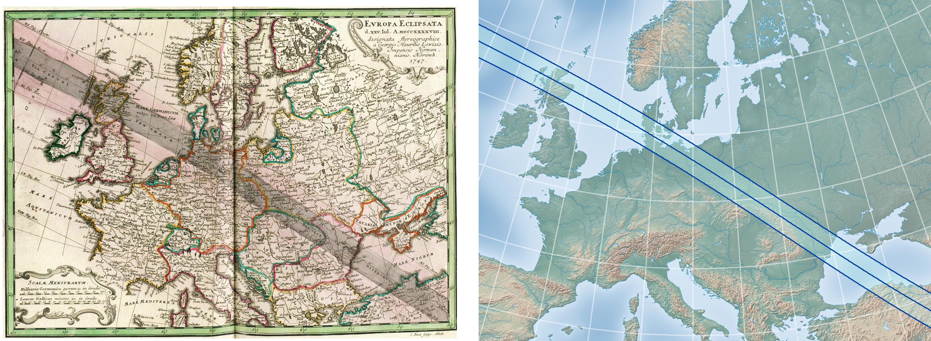
After the initial publication of the Atlas Coelestis, a revision was released in 1747 called the Atlas Novus Coelestis and contain two additional eclipse maps by George Maurice Lowiz, shown in the gallery below. These maps show the eclipse of 1748 superimposed to several hemispheric projections of the earth.


Madame Le Pauté and her eclipse map


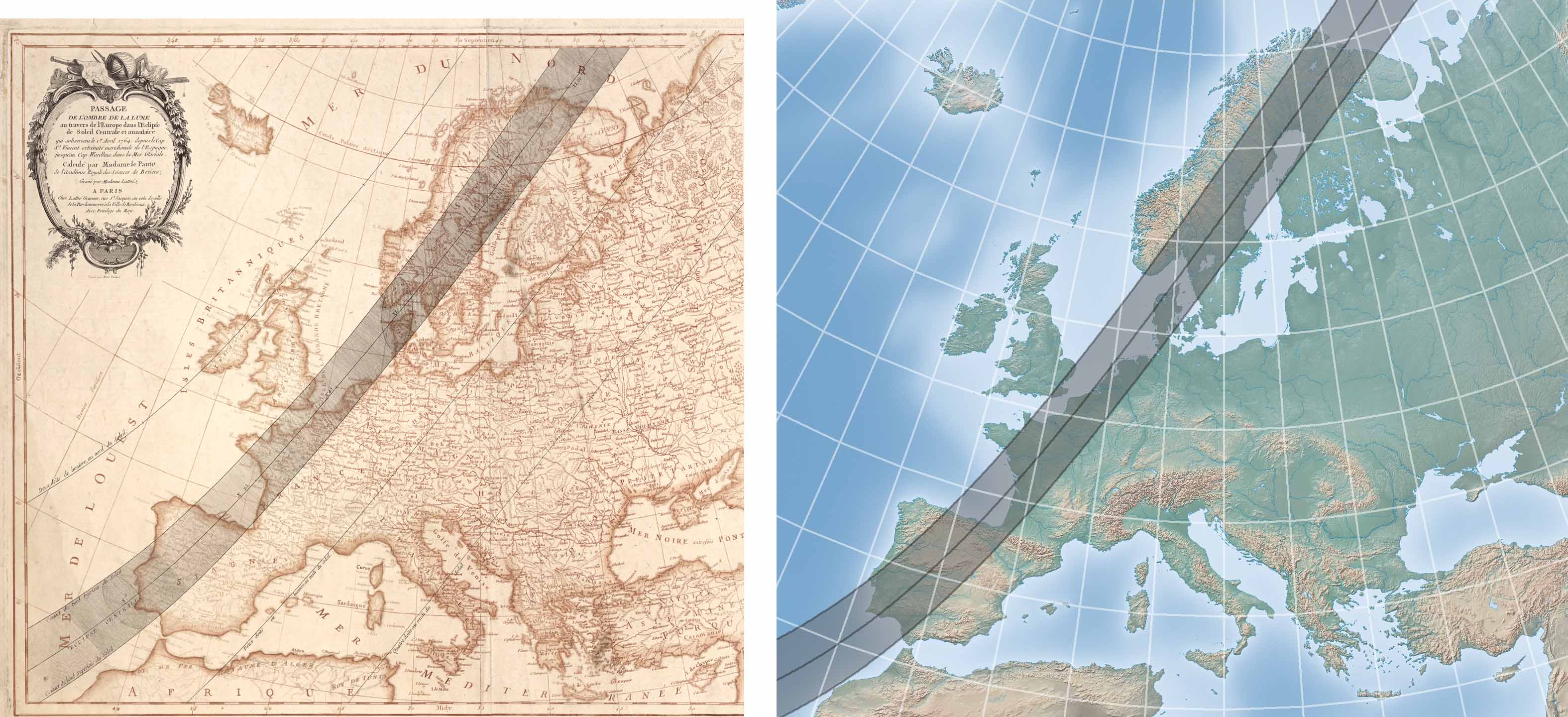
Nicole-Reine Le Pauté was an accomplished French astronomer who made many calculations for the almanac Connaissance des Temps. In 1762, she many calculations for the annular eclipse of 1764 and compiled timings for the eclipse in 15-minutes intervals across Europe in an article for the Connaissance des Temps of 1763. She applied her calculations to the publication of the map shown to the right.

Detail of Lowiz’s map of the annular eclipse of 1848. Lowiz was an astronomer with Homann’s publishing firm. It’s not known whether Doppelmayr participated in the calculations for this map.

Solar eclipse maps from 1741 to 1800

Sources


Robert van Gent describes the Atlas Coelestis and Atlas Novus Coelestis on his web site at http://www.phys.uu.nl/~vgent/doppelmayr/doppelmayr.htm with 30 high resolution plates available for download.


British maps of this era are found in http://www.fathom.com/feature/122028 and Geoff Armitage’s The Shadow of the Moon, but high-resolution images are difficult to find.


The edition of the French almanac Connaissance des Temps cited with respect to the 1764 map by Le Pauté can be found and downloaded from http://books.google.com. The high-resolution image of this map was found in the digital archives of the U.S. Library of Congress.


The maps from the Gentleman’s Magazine are from the collection of Michael Zeiler.


Map of Eclipse of Thales by William Stukeley is from Philosophical Transactions of the Royal Society, found at http://royalsocietypublishing.org/


1764 eclipse map by Joseph La Lande from Compendio d’astronomia found at

http://www.e-rara.ch/astro-eth/

Nicole-Reine Le Pauté’s map of the 1764 annular eclipse. This map was engraved with two separate copper plates, one for blank ink and one for the sepia tone. On page 22 of The Shadow of the Moon by Geoff Armitage, he states “The Le Pauté Dagelet map, engraved by Madame Lattré and Elizabeth Claire Tardieu, was unusual in that is was made entirely by women.”

The February 1764 edition of the Gentleman’s Magazine also included a story titled ‘An effectual method to destroy rats’, surely providing essential information for the day.

Eclipse maps in the first magazine


The first periodical to be known as a magazine was the Gentleman’s Magazine, published in London from 1731 until 1922. Articles were published for every significant solar eclipse of the era. The issues for February 1764 and July 1748 include attractive eclipse maps, shown to the right and below in the gallery.

Page spread with map from February 1764 Gentleman’s Magazine. Click on any image to read text.

Detail of fold-out map from July 1748 Gentleman’s Magazine.

Early diagram of eclipse cycles by Lambert


Contemporary books that discuss cycles of eclipses usually contain diagrams showing how solar and lunar eclipses are distributed into eclipse seasons.


Examples of how these eclipse cycles are described and illustrated include the “bead curtain” diagram of eclipses in Guy Ottewell’s book, The Under-Standing of Eclipses, pages 60 - 73 and the eclipse panorama diagram in Jean Meeus’ book, More Mathematical Morsels, page 68. The modern discussion of the cycles begins with the 1955 book Periodicity and Variation of Solar (and Lunar) Eclipses by Prof. George van den Bergh.


This modern analysis of eclipse cycles was preceded by an interesting book published in 1765 by the Swiss astronomer Johann Heinrich Lambert. (Lambert also invented several map projections still used today in some eclipse maps).


At the very end of Lambert’s book, which can be found at http://www.e-rara.ch/zut/content/titleinfo/961715, appears the sophisticated diagram (at right) that precedes modern illustrations of eclipse patterns by two centuries.

1765 diagram by J. H. Lambert showing patterns of solar and lunar eclipses, courtesy of Prof. Jay Pasachoff. This prescient diagram and book identifies the 29-year solar eclipse cycle known

today as the Inex cycle. This cycle was not described again until 1901 in separate papers by

John Stockwell and A.C.D. Crommelin.  (Click on image for larger view)

The title of Lambert’s book is "Beschreibung und Gebrauch einer neuen und allgemeinen Eccliptischen Tafeln, worauf alle Finsternisse des Mondes und der Erde in ihrer naturlichen Gestalt vorgestellt werden, nebst der leichtesten Art dieselbe und die daben vorkommenden Umstaende zu berechnen und zu entwerfen, durch J. H. Lambert"


which is roughly translated to


"Description and use of a new and general ecliptic table, in which all eclipses of the moon and the earth are presented in their natural form, together with the easiest kind of the same and the circumstances to calculate and design, by J. H. Lambert"