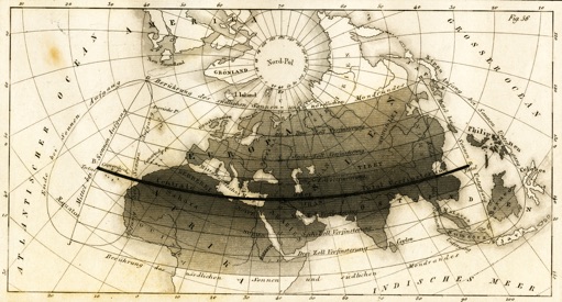
This is one of the over 1,100 historical eclipse maps served on this web site. This attractive and informative map was made by Johann Georg Heck in 1846 and documents the total solar eclipse of 1788. What is notable about this map is that it is one of the few eclipse maps to employ cartographic shading to depict the degree of partial eclipse (penumbra) outside the narrow dark path of total eclipse (umbra). This map cleanly depicts the main features of an eclipse including the thin path of totality, the northern and southern limit lines, the curves where the eclipse begins and ends at sunrise and sunset, and isomagnitudes (lines of maximum partial eclipse) at 25% intervals. As appropriate for a map of this scale, the continents and major rivers are shown and labelled along with the graticular network (lines of equal latitude and longitude), the equator, and the north pole. This map employs a stereographic map projection with oblique aspect to encompass the wide extent of a solar eclipse. This map works well because it displays precise and technical data in a clear and appealing manner and invites the map reader to imagine the spectacle of the eclipse from an interesting locale. Even in this era of advanced geographic technology and satellite data, we can learn much about mapping solar eclipses from past masters such as Heck.


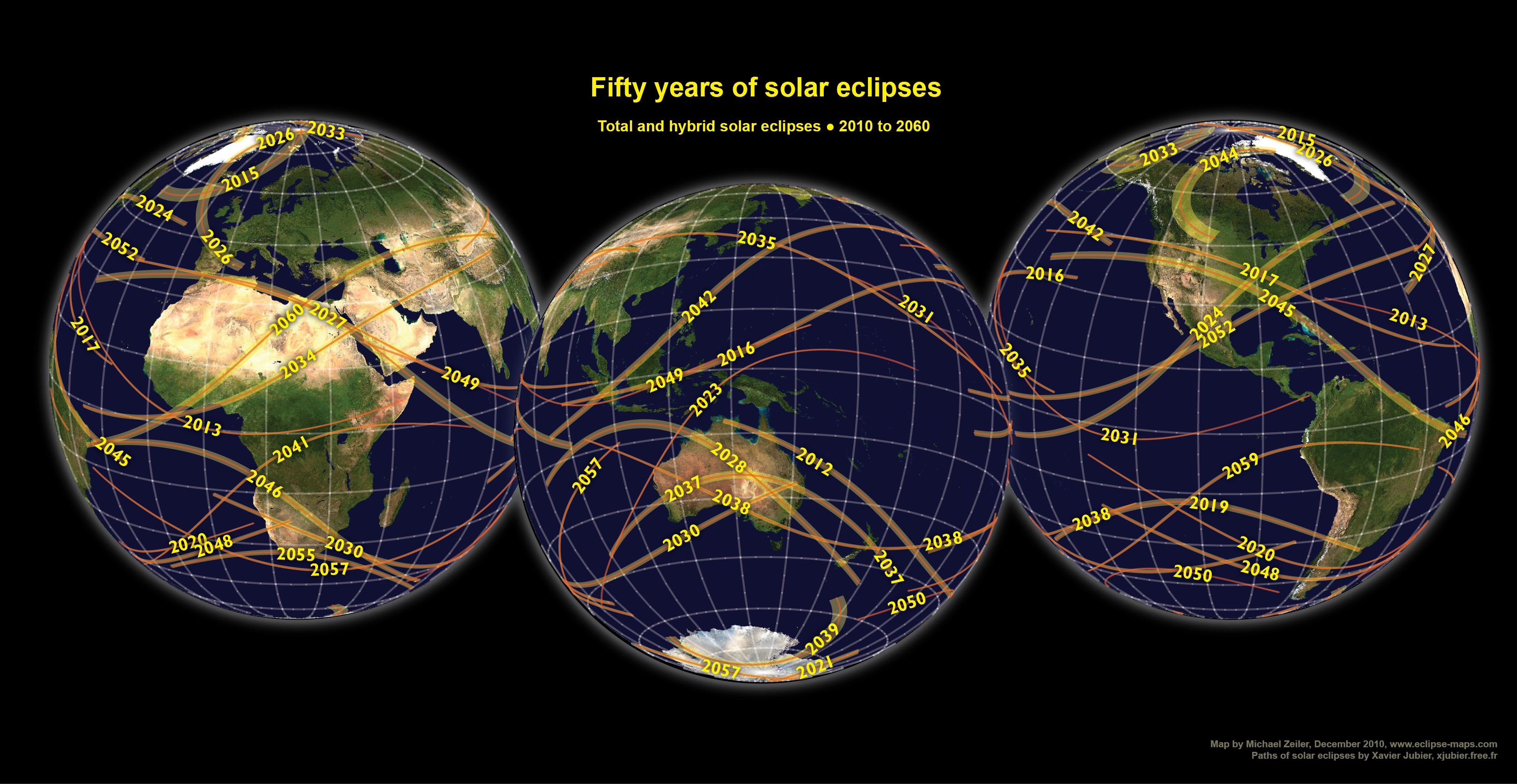
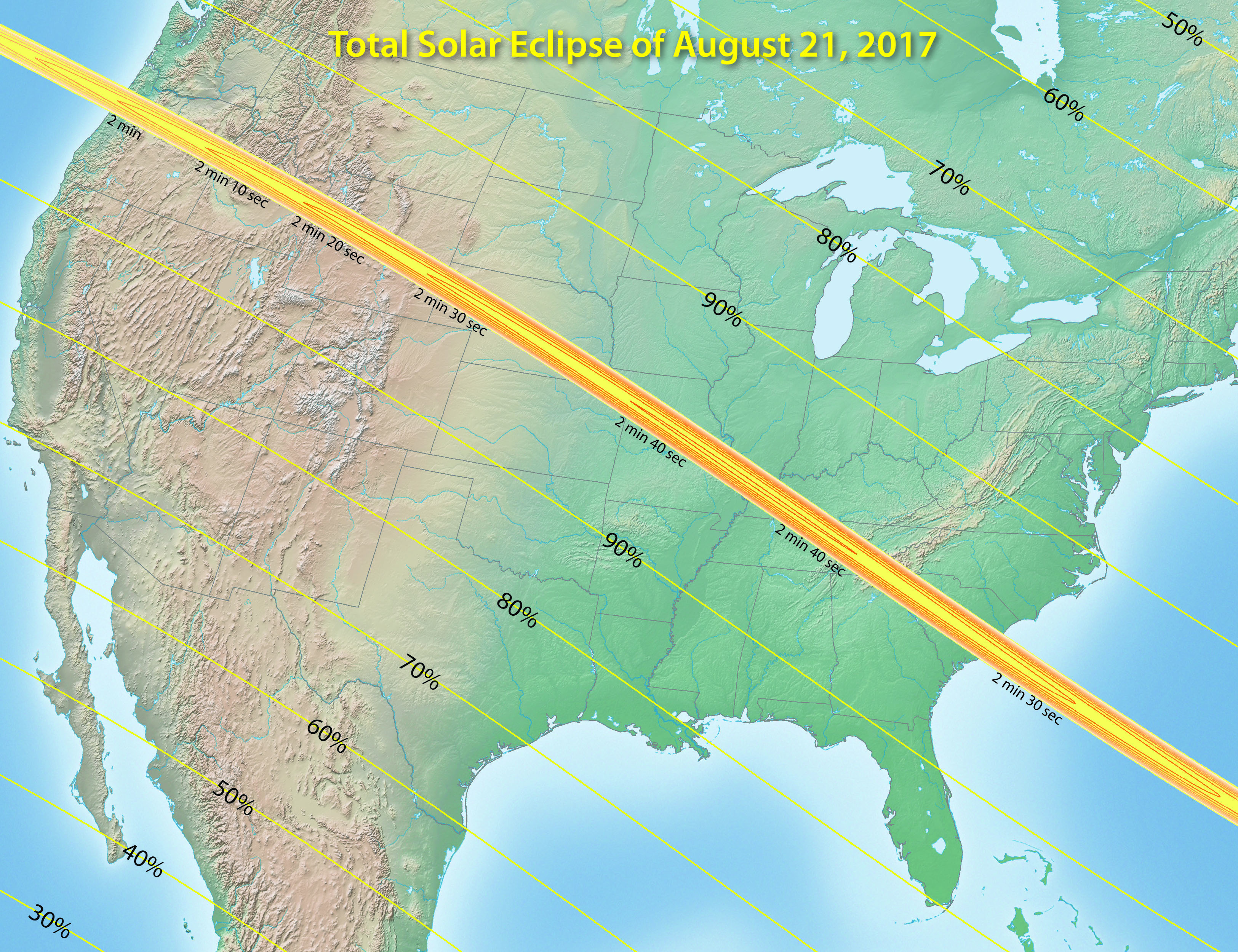
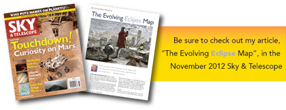
Eclipse-Maps.com is also a gallery for new eclipse maps. This overview map of the eclipse of 2017 is one of several hundred new eclipse maps that are being developed with GIS (geographic information system) software applied to millions of eclipse calculations. These maps are made with ArcGIS, the GIS software developed by my employer, Esri (www.esri.com). Any opinions expressed within this web site are my own and the eclipse maps are made during my free time.


Invitation for collaboration


The study of eclipse maps spans many historical eras, technologies, and personalities. Should you have access to interesting eclipse maps, research to contribute, corrections or clarifications, suggestions of topics to explore, requests for new eclipse maps, or comments, please share them through email to eclipsemaps@gmail.com or with comments to the twitter account @EclipseMaps.


There are many open issues in the analysis of historical eclipse maps. I would like to request the assistance of interested eclipse specialists and historians in providing further information and images of maps as outlined in this list of research topics. All contributions will be acknowledged.


Sources of historical maps


The historical eclipse maps on Eclipse-Maps.com come from many sources; private map collections, online archives, scans from astronomical almanacs, and web sites. The majority of the historical maps are in the public domain or do not have active copyrights. The sources for nearly all eclipse maps are documented in the galleries or as image metadata.


A small percentage of maps in the History page come from books and web sites with current copyright and are included for critical analysis under the Fair Use Doctrine of U.S. copyright law. Should any map author object to the inclusion of any of these maps, notify me and I will promptly remove them. Copyright laws vary around the world, please respect the laws in your jurisdiction.


Use of published maps


The new eclipse maps that I publish on this web site can be freely used for educational and non-commercial purposes. To maintain cartographic integrity, I ask that the maps not be modified. If you wish to adapt these eclipse maps for educational purposes in non-English speaking countries, I can assist you with preparing the source graphics files for translation.

Mapping the shadow of the Moon


Eclipse-Maps.com tells the story of how eclipse maps were first developed during the 17th century and their subsequent evolution to the present day.


The History page contains albums of historical eclipse maps organized by intervals of decades. The top section of each album contains commentary on the advances in eclipse maps in this era. The bottom section of each album contains significant eclipse maps from this era. (Most albums have been loaded, documentation of sources is underway.)


The Gallery page contains albums of new eclipse maps. Some albums contain maps of eclipses at 20-year and 50-year intervals around the world and continents. Other albums contain maps of eclipses in the near past and future, such as the coming eclipses in 2012 and 2017.


Eclipse-Maps.com is curated by Michael Zeiler of Santa Fe, New Mexico, USA. I work in the geographic information systems (GIS) industry and enjoy applying my professional skills to my personal interest in solar eclipses. I am fascinated by the history, science, and beauty of historical eclipse maps and I study the work of past eclipse cartographers to create new eclipse maps that are precise and expressive.


Credit where it is due


The new eclipse maps that I publish on the Gallery page of this web site are built on the work of others. My chief collaborator is Xavier Jubier, who has an indispensable web site for generating interactive eclipse maps at http://xjubier.free.fr/en/index_en.html. My main tool for eclipse computations is Solar Eclipse Maestro, which I highly recommend if you are interested in precise eclipse predictions. Xavier has kindly customized Solar Eclipse Maestro so that I have optimal input of eclipse circumstances into GIS software.


These maps apply prediction results from several eclipse researchers. Bill Kramer who runs the comprehensive web site http://www.eclipse-chasers.com. Bill developed a solar eclipse calculator and gave me invaluable assistance in starting with high-precision eclipse maps. The foundation of contemporary eclipse predictions comes from the work of Jean Meeus and Fred Espenak. They have produced the authoritative Five Millennium Catalog of Solar Eclipses at http://eclipse.gsfc.nasa.gov/SEcat5/catalog.html. A notable characteristic of the newest eclipse maps on this web site is that they incorporate eclipse timing corrections for the precise shape of the Moon.


Several persons have kindly provided research and reproductions of early eclipse maps. Robert van Gent, historian of astronomy (http://www.phys.uu.nl/~vgent/), shared his research and many images of early eclipse maps. Klaus-Dieter Herbst, historian of science, uncovered the two earliest known eclipse maps from Jena, Germany. Eli Maor, professor of mathematics at Loyola University and collector of eclipse maps, gave advice and several reproductions from his collection. Jay Pasachoff, professor of astronomy at Williams College and chair of the International Astronomical Union Working Group on Solar Eclipses (http://www.eclipses.info) provided research, advice, and eclipse map images from his collection. Sheridan Williams (http://www.clock-tower.com), director of the Computing Section of the British Astronomical Association, has kindly provided many eclipse maps from his personal collection.


Eclipse maps published by Michael Zeiler on the Gallery page of this web site are covered under a Creative Commons Attribution-NonCommercial-NoDerivs 3.0 Unported License.

The greatest show on Earth


A total solar eclipse is the most amazing spectacle in nature. Everyone should try to witness this event at least once in a lifetime. Once you’ve seen an eclipse, you will be touched for life and might be inspired to join the ranks of eclipse observers who plan trips long in advance to remote corners of the world.


Eclipse maps are the vehicle for eclipse observers to plan expeditions, study observing prospects, and relive adventures of eclipse day. Any eclipse observer will tell you that eclipse maps are vacation guides for a lifetime. You use an eclipse map to find locations for the eclipse phenomena you wish to observe. You can choose a spot along the center line to maximize your duration of totality along with good weather prospects or you can choose a point near the limit lines of totality to enjoy dramatic effects, such as extended views of the sun’s photosphere, the innermost and most colorful section of the sun’s corona.


Eclipse maps are astonishing because they dare to predict precise locations and timings of future eclipses as well as the paths of eclipses in antiquity. Each eclipse map tells a story that weaves together geographic knowledge, information visualization, scientific understanding, and artistic flourishes. Eclipse maps are remarkable artifacts of our civilization.

New: Click on this strip map to see a comprehensive overview of the Great American Eclipse of August 21, 2017

New! GreatAmericanEclipse.com is a recently-launched website by the creator of eclipse-maps.com dedicated to the total solar eclipse of August 21, 2017.


Visit GreatAmericanEclipse.com for new maps, videos, and information. Eclipse-Maps.com will continue as a repository of historic and new eclipse maps.

Eclipse t-shirts and maps here